Tuesday, February 04, 2014

Ashland BRT Snapshot Usage Calculator - Now 5-1 Cars - With BRT 2-1 Transit

Using this calculator I calculate that car riders on Ashland Avenue use five times as much of the street as bus riders on a per person basis.

After the installation of the Ashland BRT I calculate that transit riders will use twice as much of the street as car riders per person.

While that is still not fair it is more fair and forty years of unfairness favoring car riders might be paid back in as little as twenty years. However it is possible that if transit usage increases dramatically that before the twenty year payback is reached, the usage rates will have harmonized at equality. In that case we will have to extract the car rider debt some other way.

The link to the calculator is here --> https://docs.google.com/spreadsheet/ccc?key=0AhuYyrSSu7gPdFR6TVBLQVRDWVRlV0ZwNEh1X1FXZkE&usp=sharing

I believe that you can copy the spreadsheet and change the inputs to get your own calculations. If not, then let me know as that is my goal.


Before BRT


BikeTreeWalkBusCarTotal


Exclusive01.8103.26


Shared0000.22.83
Total01.810.269


After BRT


BikeTreeWalkBusCarTotal


Exclusive01.812.216


Shared0000.22.83


Total01.812.43.89


BusCar


0.26Total blocks used by vehicleCalculated from Above
5.55.5Blocks in snapshotDistance between each bus
11Speed factorHow much faster the faster vechicle goes
1260vehicles in snapshotTotal vehicles in the Snapshot
For cars used 50,60,30,40,50,30 for 5.5 blocks
551.25Persons per VehiclePer Tom Fraeser for cars


Calculations
55325Persons Total
1059.1Persons per block
1059.1Persons per block adjusted for speed
0.020.102Blocks per person usage


5.1Advantage


AFTER BRT


BusCar


2.43.8Total blocks used by vehicle
1111Blocks in snapshot
21Speed factor
1260vehicles in snapshotThis number for cars reflects the loss of a lane.
551.25Persons per Vehicle


Calculations
55325Persons Total
529.5Persons per block
1029.5Persons per block adjusted for speed
0.240.129Blocks per person usage


1.9
Advantage

 Lets call this version 1.0 as already I see some clean up that could improve it. And since there will likely be more I will wait and do as much at once as I can.

---------------------------------------------------------------------------------------------------------------
--------------------------------------------------------------------------------------------------------------
I started a formal post. Below are the appendices for that formal post. In the appendices are some explanations for some of my methodology. I'm sorry this is all so rough and I hope to bring it all together in a more polished fashion. But for now this is it.


Apendix A: Tom Kaeser

Let’s make some assumptions. Let’s assume that there are 30,000 daily bus riders on the CTA Ashland #9 line. I know the CTA says 31,000 but we are going to be doing a lot of “let’s assume” and rounding is going to be our friend.

Lets  assume that there are 400,000 non-transit, i.e. non-bus, users of the the same Ashland Avenue. For the moment we will take Tom Kaeser’s informed and educated calculation, from his link’s word for it.

So using the magic of rounding we get 7% of Ashland’s daily use is on a bus and 93% is not on a bus. We’ll just park that number for the moment.


Take Away: 93% car, 7% bus   

Who’s on the Bus
Appendix B: Static View Wrightwood to Blackhawk

Tthe #9 bus schedule on a weekday:
Ashland & Wrightwood
08:16 am
08:21 am
08:27 am
08:32 am


Ashland & Blackhawk
08:27 am
08:32 am
08:38 am
08:43 am


Wrightwood and Blackhawk are conveniently 11 blocks apart. It takes the bus a minute to go each block. The buses are five and a half minutes apart. So if we could take a picture we could see three buses on that stretch, one at Wrightwood and one around Armitage and one at Blackhawk, more or less. Five and a half minutes and five and a half blocks apart. Now lets assume that there are 55 people on each of the buses. Not unreasonable at 8:30 am. Anyway a convenient assumption as it gives us a nice round number of 10 people per block.
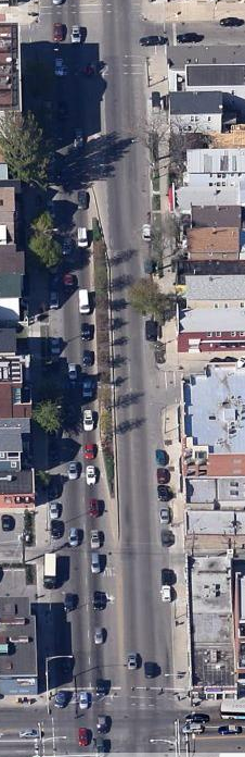
How many cars are there on each of those blocks. Actually on average, because the block between Altgeld and Fullerton (picture at right) is likely totally jammed at 8:30 am as the three way corner with Clybourn and Fullerton is a bottleneck for south bound Ashland. But then the block over the river is likely mostly empty going south. Looking at the current Google Satellite picture of that block on the southbound side one can count 40ish cars there with plenty of space for another ten to twenty more. It’s an afternoon shot.

So lets assume for the blocks going south of Wrightwood we have 50, 60, 30, 40, 50 and the next half block 30 or 260 for five and a half blocks, or 47 average per block. Lets call it 50. Kaeser would have us add another 12.5 people for his 1.25 people per car. Ok so lets compromise and say 60 non-bus users on each block. That’s a usage rate of 14% bus and 86% non-bus. (10/70 and 60/70)

So which numbers do we use? The 7% and 93% or the 14% and 86%. I say we use the 14/86 numbers because the potential for carmageddon is during the rush hours. Therefore the numbers derived from our eyeballing the street at an instant of time in the morning are more relevant in assessing this carmageddon.

Take Away: 86% car, 14% bus

Appendix C: cjlane percents

Disqus user cjlane: -> http://chi.streetsblog.org/2014/01/27/daniel-hertz-sets-the-record-straight-on-brt/#comment-1222166862
"nearly half the travelers on the street"

“Look upthread at the chart of the ridership of the 9--the peak in any stretch is 6,000 per day. Credit BRT with a 50% increase (which is beyond the projections I have seen) and you get peak daily ridership of 9,000 in the busiest stretch. The busiest stretches for total vehicles are presently around 36,000 per day. Multiple that by 1.5/vehicle (happy to use a better factor, if you have one) you have peak PEOPLE traveling on Ashland of 54,000 (not counting transit riders).
BRT improves travel times for 15% of users, while degrading it for 85%.”

Now I would use Tom Fraesers number of 1.25 riders per car. That would give us 45,000 car riders or 51,000 total current users at the busiest times. 6/51 = 12% and 45/51 = 88%. So his numbers are close to my model.

Take Away: 88% car, 12% bus riders

How is the Street Being Used


Appendix D: Current Street Usage by Geometry

Now for something completely different lets run some assumptions over street usage. For this I am creating two categories, exclusive usage and shared usage. In the end I will pretty much ignore the difference and just do calculations using the total of the two. But it’s still an interesting exercise.

As an example of exclusive usage picture the sidewalk along the edge of the street. That’s a usage I would call exclusive for walkers or pedestrians. For shared usage picture the right hand travel lane. It is used by cars and buses both and trucks and bikes too. That’s a shared lane. Besides the sidewalk there are three other exclusive lane users: parked cars, left turning cars and trees. For our purposes I consider trucks and cars synonymous users. And because the street is so hostile for bikers I consider them non-users. Therefore since buses effectively never turn left, I consider the partial left turn lane exclusive use by cars. Likewise you never see a parked bus (yes except breakdowns, come on we can ignore that here as well.) And trees, well, of course, nobody but the birds and squirrels share that space, so again exclusive.
Now going back to our snapshot view of the street as a static moment in time, I round the amount of space used by the various users to some tenth of a block. Therefore bus stops in the curb lane count as one tenth of a shared lane. It’s actually quite a bit less but a tenth is as low as I go. Remember there is only one bus per 5.5 blocks and when the bus is not there the space is shared by right turning cars. In the same vein I count the left turn lane as two tenths of an exclusive use lane. The other eight tenths is exclusive tree use lane.

I pretend that the curb lane is only half used for parking. The rest is shared use for…. Well really nothing but cars except the right turn lane which is not really all the other half. But whatever, it’s not really going to be important in the end because I will be using totals of shared and exclusive.

The big assumption is that the left travel lane is an exclusive lane for cars. Really it’s of little use for buses except for getting around double parkers etc.

Finally the sidewalk and parkway are half lanes in each direction for walkers and trees.

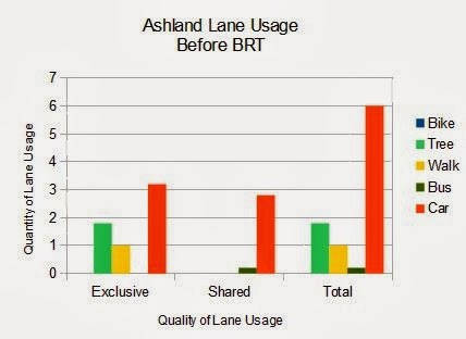
Here’s the table and the graph repeated from above after that:


Current Ashland Ave Lane Usage Assignments


  Bike
 Tree
 Walk
 Bus
 Car
 Total
Exclusive
0
1.8
1
0
3.2
6
Shared
0
0
0
0.2
2.8
3
Total
0
1.8
1
0.2
6
9
Lane usage divided by Car + Bus (6.2)


3%
97%


If we ignore the other users besides buses and cars we have the following percentages:

Of the total 6.2 lanes used by buses and cars 3% is used by buses (0.2/6.2) while 97% is used by cars (6/6.2). Or to put it another way 14% of the users of the street get 3% of the street to use while 86% get 97% of the street.

To do a lane per user calculation we need to double the users above because we are counting both directions: one hundredths (.01) (.2 lanes divided by 20 riders) of a lane per bus rider and five hundredths (.05) of a lane (6 lanes / 120 riders) per car rider.

1/100ths of a lane per Bus rider - 5/100ths of a lane per Car rider. Car riders get 5 times the street space as bus riders.

Takeaway: 5 to 1 advantage car over bus.

Appendix E: Street usage with BRT

Here the difficulty is trying to figure out the headway between the buses and the number of riders on the bus. I assume that the buses go twice as fast as now and therefore half the buses will suffice for the same capacity as is transported now. So I assume a five and a half minute headway with an 11 block separation.

Wednesday, January 29, 2014

400,000

Tom Kaeser in ten page letter sent to the CTA: (pdf)
"When further multiplied by a factor of 1.25 passengers per vehicle, we find that roughly 400,000 non-bus passengers per day may be using Ashland, an impressive number compared to the CTA Route 9 ridership of roughly 31,000 per day."
A number way beyond the 50,000 that I used in the previous post.

It would mean that on a per capita basis 93% of the users of Ashland would get 61% of the street while 7% of the users would get 39% of the street. Is that fair? Don't go away. There is another way of looking at it that I will discuss, soon, I hope.

Sunday, January 26, 2014

Ashland BRT is More Fair (Updated)

Above is the current lane usage of Ashland Avenue. I am counting nine lanes of of possible street usage. There are two lanes of dedicated exclusive usage, one in each direction, for pedestrians and trees in the parkways on either side of the street. Bikes and cars and buses are denied usage of the sidewalks and therefore there is a half lane in each direction for the exclusive travel usage by pedestrians. Even though pedestrians are allowed to cross over the planted parkway I consider there to be two half lanes of dedicated exclusive usage for trees and plantings. In addition there is a median strip in the middle of Ashland that I have generously assigned 8/10s of a lane as dedicated to trees and plantings as well.

Current Ashland Ave Lane Usage Assignments

   Bike    Tree   Walk   Bus   Car   Total
Exclusive 0 1.8 1 0 3.2 6
Shared 0 0 0 0.2 2.8 3
Total 0 1.8 1 0.2 6 9


Since buses effectively don't use the lane next to the median I assign that lane to exclusive use of cars. (And trucks which I treat like cars for the purposes of this analysis.) I also count the parking usage one either side of the street as two half lanes exclusive car usage.  And further I assign two tenths of a lane in the median as exclusive lane for car turning. Again buses effectively do not use it. That's how I get 3.2 lanes of dedicated exclusive car lane usage.

Three lanes remain for shared usage for bikes, buses, and cars. Ashland is currently so hostile a street for biking that the effective rate of biking is less than one tenth a lane and I round their use down to zero usage. (Bikes would be dark blue if they showed up in the graph.)

I assume one bus per three blocks is sharing the road with either 99 cars or 97 cars for three blocks depending on whether we count the bus as one vehicle or three cars equivalent. In any case each bus uses less than one tenth a lane or two tenths for both directions rounded up to the next tenth of a lane in each direction. I believe that I am being generous with that calculation.

Is it fair that 30,000 daily users get two tenths of a lane while 50,000 [* see update at bottom] users get six lanes? It's a rhetorical question.

Bus Rapid Transit

Below is how Ashland lane usage will change with the installation of Bus Rapid Tranist (BRT):


After BRT

  Bike   Tree   Walk   Bus   Car   Total
Exclusive 0 1.8 1 2.2 1 6
Shared 0 0 0 0.2 2.8 3
Total 0 1.8 1 2.4 3.8 9

Cars still have the most lane usage of any mode which reflects their current status of the largest per person usage. The big change is that buses now have exclusive dedicated lanes and cars would only have the parking usage as exclusive. Meanwhile buses now gain an entire lane of exclusive use in each direction as well as two tenths of the median lane for station usage and would keep the existing two tenths for local bus usage.

If we use the numbers of 30,000 bus riders and 50,000* car riders, which again I consider generous to cars, and 2.4 bus lane usage and 3.8 car lane usage the per person percentage usage balances out nicely with the lane percent usage:

38% of the people using the street via bus are using 39% of the lanes, while 63% of the people using the street with their cars are using 61% of the lanes.

It is possible that the 50,000* number is high and will decrease after the BRT is installed. It is likely that the 30,000 number will increase significantly after the BRT is installed. Yet the lanes assigned to each usage will remain the same making it once again unfair to bus riders. But not as unfair as now.

* UPDATE (1/29/2014): See my next posting above somewhere. Teaser: 400,000?

Monday, January 06, 2014

Sub-urban

As for defending the concept of urbanism, I personally am not afraid to insert a hyphen where it belongs. Since the best defense is often a good offense, and the best offensive is often subtle, a subtle reminder of your roots can not be beaten. Of course, sub-urban written out hyphenated like that is anything but subtle in and of itself, so one must construct a milieu such that when it is finally sprung on your reader it seems actually natural and proper.

I do not fault those who abandoned the city during those times of willful neglect by those Jarrett rightfully calls imperialists. It gave those who stayed and were later joined by the children of those who left a chance to grow the culture of urbanism in a denser supportive medium. Our successes are now attractive. So attractive that we find ourselves needing to be able to inform, and to inform we need clear vocabulary. We need to inform sub-urbanites who wish to move to the city, of course.

For me urbanism is a written culture. I rarely get a chance to speak it. I can only imagine the subtle jolt one might experience on hearing suburban pronounced sub-urban. Again proper use of this now charged word is important. We do not want to imply that anyone personally is inferior or lacking. It was this concern that no one feel slighted that caused the purveyors of the concept to push the "b" away so as to disappear the notion of "sub." "Sa-Berben" now had the dual effect of disappearing the other concept as well. "Urban" became "burban" as if it were an intoxicant. And to disappear ideas of urbanism even further there was the shorthand of "burbs," as in "Oh we live in the burbs." It's a process of alienation that we can now to some extent counteract with a judicious use of a hyphen.

See here: http://www.humantransit.org/2014/01/questionable-word-watch-urbanism.html

Sunday, December 22, 2013

The Ashland BRT and the Performance Culture of Opposition

There is a very defined and well understood culture of opposition. If you look at the recent community presentation for submitting comments to the Ashland BRT, and the stark dis-settlement of the opposition to the BRT by the format of that meeting then you can see what I mean. (See this Chi.StreetsBlog.org article )They came to the meeting prepared to "raise a ruckus." That I can even describe their tactic with that colloquialism illustrates what I mean by culture of opposition. When instead of a traditional town hall format they expected, they were presented with a tables and placards open ended presentation of the plan with presenters ready to answer questions, they were dumb-founded.

Suddenly they were floundering. There was no platform for them to perform upon. There were no microphones attached to a sound amplification system at the ready for their performance. And especially vexing effect of this loss was that even were there television cameras at the ready, their performance depended upon the missing amplified stage.

In ones imagination it is easy to walk through the way they imagined it would play out. They would arrive at the event with at least five or six of them ready to play a set-piece role. When their turn to speak came, with their first speaker, an electric buzz of expectation would grip the room as their forces would draw the focus to the moment with shushes of those around each of the six, with shushed whispers of "listen to this" to those around, and a reverent payment of attention to the first of their speakers.

Their speaker would then begin, and like a preacher in a church would rouse their forces to righteous anger. An anger that would elicit confirming responses from the rest of them. Anger over a list of offensives that would rain on the entire community should the proposed changes come to pass. And when the first speaker was done the other five would await their turn to repeat the same performance over again. Each of them would be competing against the others of their group for the grand prize to be awarded to the winner; the prize of appearing on the evening news.

This is a performance much more difficult for the people supporting the changes to mount. Especially if the supporting side is organized solely by a government entity which by definition is not allowed righteous anger. And without righteous anger media are left bereft of attention grabbing drama for their audiences. Indeed the media are dependent upon the calm rational proponents to provide the unemotional background that will so highlight the righteous anger foregrounded by the opposition.

And you know quite well that the CTA knew very well what it was they were doing when they denied the opposition this opportunity of media attention. That fact, that the CTA knew what it was doing and knew to do it, was what first began to tell me that the fix was in. In this case a good fix of a dense urban environment that needs a denser transit in the form in this case of BRT. But a fix too in the sense that the mayor, not someone I particularly support, was likely going to stand behind this project to the end. A mayor who knows that he runs the aldermanic show and can allow individual alderman their luxury of appearing to be independent of the mayor and oppose the BRT. A mayor who knows that he may very well gain as many CTA rider votes as he loses from Ashland car drivers and business owners. Votes that he can well afford to lose anyway.

Add to that the fact that, as I have only learned in the last few months, that his hand picked head for the CDOT (Chicago Dept. of Trans.), Gabe Klein (recently having moved on) was picked because of his success in setting up bicycle sharing in DC. It begins to suggest that Rahm has bought into the urbanist ideological agenda of mass transit over individual transit in the densest parts of the city.

All this strongly suggests to me that the Ashland BRT is most definitely going to happen.

Friday, December 20, 2013

My Comments to Ashland BRT Environmental Assessments

Heres my comment to the Ashland BRT assessment team. The numbers in parentheses refer to the location on the Appendex G location numbers. Some of it is pure wish list, but what the hey?

Ashland BRT Assessment Team,

Please consider the following comments:

1) The station placement for stations at or near el stops should allow for as direct a connection as possible.

  • (911+00 Location number on AppendexG) For example for the Roscoe Street stop should be north of Roscoe. That would save crossing of Roscoe Street for BRT users transferring to the Paulina/Lincoln Brown Line Station. In the future a stop-lighted crosswalk under the el tracks and a direct paved and roofed path to the station could be built with a new set of stairs at the eastern end of the platform installed to further reduce the walking connection to the brown line.
  • (765+00) At the Blue Line at Milwaukee-Division a station with direct stairs down to the subway station would be the Gold Standard.
  • (697+00)  At the Green/Pink Line connection at Randolf? it would behoove us to have a direct stairway connection from the BRT station directly into the station with no street crossing required.
  • (662+00)  At the Blue line Eisenhower place the BRT station on the bridge over the highway with long covered walks to one or both of  the stations in either direction?
  • (529+00) At the Orange line you seem to have that one covered.
  • (310+00) At the 63rd Green line the BRT aligns exactly with the station. Again direct stairs would be the Gold Standard.
  • ·    The experience should be as close to an el to el connection as is possible. But perhaps we are trying to save money in the beginning stages and are saving these kinds of treatments for later. Fine as long as we do not step on ourselves later.
2). To accommodate left turners, should that become absolutely necessary, I would recommend a solution where both left and right turns are done from the same current right turn lane. Lefts allowed only on a left arrow. I realize that it is several compromises of normal practice.

3) I have seen concerns about costs of a “failed” project where we might have to tear out stations. Perhaps prefabricated stations that are built in functional units to be combined in various combinations that are towed to the site for quick installation on simple concrete pads could be considered. Then when the BRT is a great success the pre-fab stations could be replaced with concrete and then towed to the next BRT “trial” at Western Avenue.

4) It would be best if the BRT were to extend to a point where it could connect directly to the north Red Line, either at Howard or Loyola and Devon.

5) For sure the Western BRT should extend to Howard Red line either via Howard or special pavement along the Yellow line.

(EDIT 12/22/2013: And here as an FYI is their reply email (standard, canned, but expected and works for me.)

Thank you for your interest in the Ashland Bus Rapid Transit (BRT) project.  November 19, 2013 to December 20, 2013 is the official 30-day comment period to collect formal comments on the Environmental Assessment (EA) for the project.  This comment period is part of a process established by the federal government.  As such, any comments in your email will become part of the formal record for the EA and the project.
At the end of the comment period, responses to comments will be issued as an appendix to the final EA.  These responses will be available through CTA’s website.  You will receive an email when they are posted, as well as any other email updates that are sent regarding the Ashland BRT project.
Comments will inform the next phase of design.  Comments received before or after the formal comment period will also be taken into account and help inform the next phase of design, but may not be included in the official record for the Environmental Assessment.

Friday, December 13, 2013

Ashland BRT Left Turn Accomodation

Currently there is some controversy about the potential elimination of left turns in the Ashland BRT (Bus Rapid Transit) proposal by the CTA (Chicago Transit Authority.) Let me say at the outset that I support the Ashland BRT no matter the specific design. I would, of course, prefer the design that meets all the current gold standards of BRT design. The primary ones are: 1) an exclusive dedicated bus lane, 2) fare collection before boarding, 3) bus driver control of stop light signals. It is worth getting it right on Ashland as Ashland paves the way for other BRTs such as Western Avenue.

However, I do feel that it is important that as many stake-holders as possible sign on to all critical design elements. Therefore, in order to appease demands of left turner lobby, I would support such outside-the-box approaches as the one I present here:


It is not to scale. Everything is eye-balled. When push comes to shove there may well be some element that simply will not fit.

The out-of-the-box element that makes this design work is the combination of both left and right turns from a single lane (orange in the diagram.)  Left turns would be allowed only during signals. Right turns would be allowed anytime but would be constrained by the presence of left turners. I get that combining the turning lanes into one would be less than ideal. But transit riders have lived with less than ideal design for a long time. My argument is that for 50 years automobiles have been catered and deferred to with street design, even where they don't deserve it in urban settings. I say it is now time to defer to transit needs over car needs in those settings.

The major drawback with this design is that it costs more because two BRT loading stations are required instead of one. That means all feature elements for transit use, fare collection, turnstiles, roofing, signage and the like must be duplicated. However, a major additional feature with this placement of the two stations is that it can be shared by the local bus allowing for easy off / easy on transfers from a local bus to a BRT bus going the same direction.

Since the local bus would pull into the car lane for loading and unloading, the BRT bus could pull ahead. Indeed such a design would make it practical to place the BRT stations at one mile separations as users could easily change buses.

It is my contention that the extra costs of additional stations should come from the streets and highways budgets because cars are the ones benefiting from the ability to turn left. If it were up to me as a very irregular south-of-Irving Ashland driver I'd say can the left turns as I can live without them.

UPDATE 12/16/13: Interestingly the international standard for BRT's have a score that is highest for BRT's that allow no left turns. Another reason to ban them -> http://www.itdp.org/microsites/the-brt-standard-2013/brt-basics/intersection-treatments/