Using this calculator I calculate that car riders on Ashland Avenue use five times as much of the street as bus riders on a per person basis.
After the installation of the Ashland BRT I calculate that transit riders will use twice as much of the street as car riders per person.
While that is still not fair it is more fair and forty years of unfairness favoring car riders might be paid back in as little as twenty years. However it is possible that if transit usage increases dramatically that before the twenty year payback is reached, the usage rates will have harmonized at equality. In that case we will have to extract the car rider debt some other way.
The link to the calculator is here -->
https://docs.google.com/spreadsheet/ccc?key=0AhuYyrSSu7gPdFR6TVBLQVRDWVRlV0ZwNEh1X1FXZkE&usp=sharing
I believe that you can copy the spreadsheet and change the inputs to get your own calculations. If not, then let me know as that is my goal.


| Before BRT |
|
|
|
|
|
|
|
|
|
| Bike | Tree | Walk | Bus | Car | Total |
|
|
|
| Exclusive | 0 | 1.8 | 1 | 0 | 3.2 | 6 |
|
|
|
| Shared | 0 | 0 | 0 | 0.2 | 2.8 | 3 |
|
| Total | 0 | 1.8 | 1 | 0.2 | 6 | 9 |
|
|
|
|
|
|
|
|
|
|
|
|
|
| After BRT |
|
|
|
|
|
|
|
|
|
| Bike | Tree | Walk | Bus | Car | Total |
|
|
|
| Exclusive | 0 | 1.8 | 1 | 2.2 | 1 | 6 |
|
|
|
| Shared | 0 | 0 | 0 | 0.2 | 2.8 | 3 |
|
|
|
| Total | 0 | 1.8 | 1 | 2.4 | 3.8 | 9 |
|
|
|
|
|
|
|
|
|
|
|
|
|
| Bus | Car |
|
|
|
|
|
|
|
|
| 0.2 | 6 | Total blocks used by vehicle | Calculated from Above |
| 5.5 | 5.5 | Blocks in snapshot | Distance between each bus |
| 1 | 1 | Speed factor | How much faster the faster vechicle goes |
| 1 | 260 | vehicles in snapshot | Total vehicles in the Snapshot
For cars used 50,60,30,40,50,30 for 5.5 blocks |
| 55 | 1.25 | Persons per Vehicle | Per Tom Fraeser for cars |
|
|
|
|
|
| Calculations |
|
| 55 | 325 | Persons Total |
|
| 10 | 59.1 | Persons per block |
|
| 10 | 59.1 | Persons per block adjusted for speed |
|
| 0.02 | 0.102 | Blocks per person usage |
|
|
|
|
|
| 5.1 | Advantage |
|
|
|
|
|
|
| AFTER BRT |
|
|
|
|
|
| Bus | Car |
|
|
|
|
|
|
| 2.4 | 3.8 | Total blocks used by vehicle |
|
| 11 | 11 | Blocks in snapshot |
|
| 2 | 1 | Speed factor |
|
| 1 | 260 | vehicles in snapshot | This number for cars reflects the loss of a lane. |
| 55 | 1.25 | Persons per Vehicle |
|
|
|
|
|
|
| Calculations |
|
| 55 | 325 | Persons Total |
|
| 5 | 29.5 | Persons per block |
|
| 10 | 29.5 | Persons per block adjusted for speed |
|
| 0.24 | 0.129 | Blocks per person usage |
|
|
|
|
|
|
|
|
|
| 1.9 |
| Advantage |
|
Lets call this version 1.0 as already I see some clean up that could improve it. And since there will likely be more I will wait and do as much at once as I can.
---------------------------------------------------------------------------------------------------------------
--------------------------------------------------------------------------------------------------------------
I started a formal post. Below are the appendices for that formal post. In the appendices are some explanations for some of my methodology. I'm sorry this is all so rough and I hope to bring it all together in a more polished fashion. But for now this is it.
Apendix A: Tom Kaeser
Let’s make some assumptions. Let’s assume that there are 30,000 daily bus riders on the CTA Ashland #9 line. I know the CTA says 31,000 but we are going to be doing a lot of “let’s assume” and rounding is going to be our friend.
Lets assume that there are 400,000 non-transit, i.e. non-bus, users of the the same Ashland Avenue. For the moment we will take Tom Kaeser’s informed and educated calculation, from his link’s word for it.
So using the magic of rounding we get 7% of Ashland’s daily use is on a bus and 93% is not on a bus. We’ll just park that number for the moment.
Take Away: 93% car, 7% bus
Who’s on the Bus
Appendix B: Static View Wrightwood to Blackhawk
Tthe #9 bus schedule on a weekday:
Ashland & Wrightwood
|
08:16 am
|
08:21 am
|
08:27 am
|
08:32 am
|
|
|
|
|
Ashland & Blackhawk
|
08:27 am
|
08:32 am
|
08:38 am
|
08:43 am
|
|
|
|
|
Wrightwood and Blackhawk are conveniently 11 blocks apart. It takes the bus a minute to go each block. The buses are five and a half minutes apart. So if we could take a picture we could see three buses on that stretch, one at Wrightwood and one around Armitage and one at Blackhawk, more or less. Five and a half minutes and five and a half blocks apart. Now lets assume that there are 55 people on each of the buses. Not unreasonable at 8:30 am. Anyway a convenient assumption as it gives us a nice round number of 10 people per block.
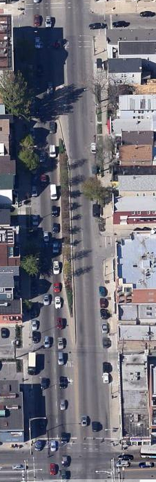 How many cars are there on each of those blocks. Actually on average, because the block between Altgeld and Fullerton (picture at right) is likely totally jammed at 8:30 am as the three way corner with Clybourn and Fullerton is a bottleneck for south bound Ashland. But then the block over the river is likely mostly empty going south. Looking at the current Google Satellite picture of that block on the southbound side one can count 40ish cars there with plenty of space for another ten to twenty more. It’s an afternoon shot.
So lets assume for the blocks going south of Wrightwood we have 50, 60, 30, 40, 50 and the next half block 30 or 260 for five and a half blocks, or 47 average per block. Lets call it 50. Kaeser would have us add another 12.5 people for his 1.25 people per car. Ok so lets compromise and say 60 non-bus users on each block. That’s a usage rate of 14% bus and 86% non-bus. (10/70 and 60/70)
So which numbers do we use? The 7% and 93% or the 14% and 86%. I say we use the 14/86 numbers because the potential for carmageddon is during the rush hours. Therefore the numbers derived from our eyeballing the street at an instant of time in the morning are more relevant in assessing this carmageddon.
Take Away: 86% car, 14% bus
Appendix C: cjlane percents
Disqus user cjlane: -> http://chi.streetsblog.org/2014/01/27/daniel-hertz-sets-the-record-straight-on-brt/#comment-1222166862
"nearly half the travelers on the street"
“Look upthread at the chart of the ridership of the 9--the peak in any stretch is 6,000 per day. Credit BRT with a 50% increase (which is beyond the projections I have seen) and you get peak daily ridership of 9,000 in the busiest stretch. The busiest stretches for total vehicles are presently around 36,000 per day. Multiple that by 1.5/vehicle (happy to use a better factor, if you have one) you have peak PEOPLE traveling on Ashland of 54,000 (not counting transit riders).
BRT improves travel times for 15% of users, while degrading it for 85%.”
Now I would use Tom Fraesers number of 1.25 riders per car. That would give us 45,000 car riders or 51,000 total current users at the busiest times. 6/51 = 12% and 45/51 = 88%. So his numbers are close to my model.
Take Away: 88% car, 12% bus riders
How is the Street Being Used
Appendix D: Current Street Usage by Geometry
Now for something completely different lets run some assumptions over street usage. For this I am creating two categories, exclusive usage and shared usage. In the end I will pretty much ignore the difference and just do calculations using the total of the two. But it’s still an interesting exercise.
As an example of exclusive usage picture the sidewalk along the edge of the street. That’s a usage I would call exclusive for walkers or pedestrians. For shared usage picture the right hand travel lane. It is used by cars and buses both and trucks and bikes too. That’s a shared lane. Besides the sidewalk there are three other exclusive lane users: parked cars, left turning cars and trees. For our purposes I consider trucks and cars synonymous users. And because the street is so hostile for bikers I consider them non-users. Therefore since buses effectively never turn left, I consider the partial left turn lane exclusive use by cars. Likewise you never see a parked bus (yes except breakdowns, come on we can ignore that here as well.) And trees, well, of course, nobody but the birds and squirrels share that space, so again exclusive.
Now going back to our snapshot view of the street as a static moment in time, I round the amount of space used by the various users to some tenth of a block. Therefore bus stops in the curb lane count as one tenth of a shared lane. It’s actually quite a bit less but a tenth is as low as I go. Remember there is only one bus per 5.5 blocks and when the bus is not there the space is shared by right turning cars. In the same vein I count the left turn lane as two tenths of an exclusive use lane. The other eight tenths is exclusive tree use lane.
I pretend that the curb lane is only half used for parking. The rest is shared use for…. Well really nothing but cars except the right turn lane which is not really all the other half. But whatever, it’s not really going to be important in the end because I will be using totals of shared and exclusive.
The big assumption is that the left travel lane is an exclusive lane for cars. Really it’s of little use for buses except for getting around double parkers etc.
Finally the sidewalk and parkway are half lanes in each direction for walkers and trees.
Here’s the table and the graph repeated from above after that:
Current Ashland Ave Lane Usage Assignments
|
|
|
|
|
|
|
|
Bike
|
Tree
|
Walk
|
Bus
|
Car
|
Total
|
Exclusive
|
0
|
1.8
|
1
|
0
|
3.2
|
6
|
Shared
|
0
|
0
|
0
|
0.2
|
2.8
|
3
|
Total
|
0
|
1.8
|
1
|
0.2
|
6
|
9
|
Lane usage divided by Car + Bus (6.2)
|
|
|
|
3%
|
97%
|
|

If we ignore the other users besides buses and cars we have the following percentages:
Of the total 6.2 lanes used by buses and cars 3% is used by buses (0.2/6.2) while 97% is used by cars (6/6.2). Or to put it another way 14% of the users of the street get 3% of the street to use while 86% get 97% of the street.
To do a lane per user calculation we need to double the users above because we are counting both directions: one hundredths (.01) (.2 lanes divided by 20 riders) of a lane per bus rider and five hundredths (.05) of a lane (6 lanes / 120 riders) per car rider.
1/100ths of a lane per Bus rider - 5/100ths of a lane per Car rider. Car riders get 5 times the street space as bus riders.
Takeaway: 5 to 1 advantage car over bus.
Appendix E: Street usage with BRT
Here the difficulty is trying to figure out the headway between the buses and the number of riders on the bus. I assume that the buses go twice as fast as now and therefore half the buses will suffice for the same capacity as is transported now. So I assume a five and a half minute headway with an 11 block separation.
